The Weekly Watch
On the Beach

For the last week we've been on the gulf coast to enjoy the beautiful beaches and to do a bit of birding. Last week was a bird banding to inventory the migration, and this weekend is a birding festival. I hope I'll return home with some great photos which I will share. In the meantime, I've reposted a visit to the to the Gulf from a few years ago in March.
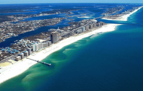
We are attracted to the shore. Some say it hearkens back to the womb...our mother's heartbeat and sounds of amniotic fluid. One thing is for sure. We are loving our beaches to death...at least here on the Gulf Coast. Last week we made it to the river delta. Join me as we continue our journey along Alabama's small strip of beaches and into the wilds of the Mississippi coast.

Doesn't it always come back to empires? Why does Alabama have a coast at all? (3 min)
https://www.youtube.com/watch?v=vC2EDB6ojn0
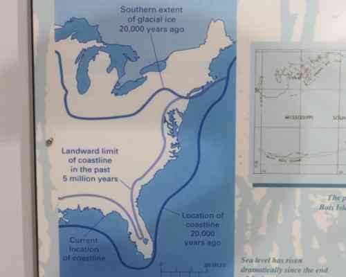
Coastlines have always been in a state of flux as Ocean levels rise and fall with the coming and going of ice ages. Nature is both constant and ever changing. Once the bay was far out into today's Gulf.
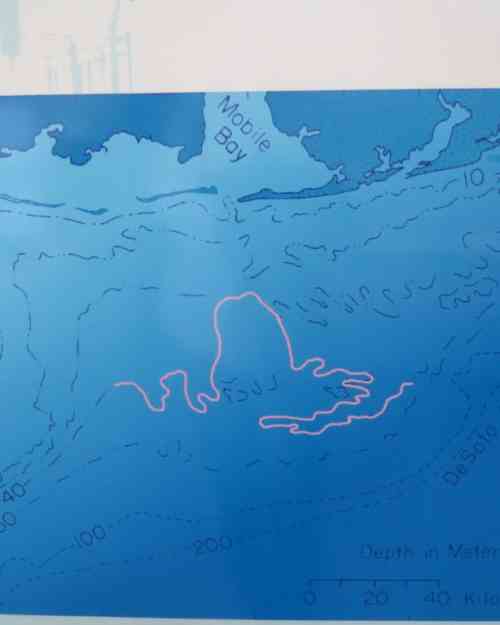
Off the coast is a 60,000 year old forest...remnants of an ancient ice age.
https://www.youtube.com/watch?v=PKm0eRfFFfo (27 min)
https://www.youtube.com/watch?v=xTsGMwGxNAU (7 min news story about the 27 min film)
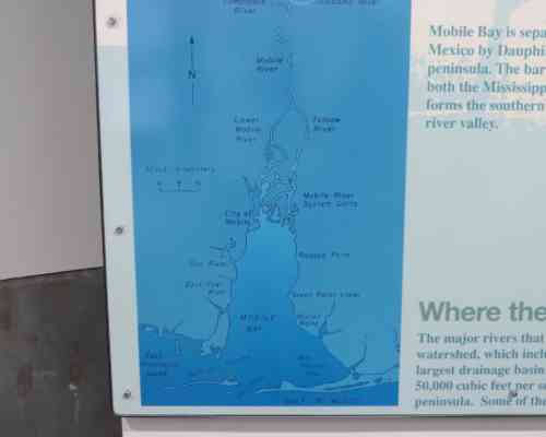
Mobile Bay is shallow only averaging 10 feet deep. They dredge a 500 foot wide channel for large ships. Since my last visit a few years ago, there are so many new natural gas wells... the the bay seems crowded with them. The bay is swept clean regularly from the river drainage and is a relatively clean and productive fishery. Remember Forest Gump's shrimping operation?
Two world view...on the sand spit of Fort Morgan on the East tip of Mobile Bay.
Dune gone it! They have gone. Dozed down to build beachfront property.
https://www.floridaocean.org/uploads/docs/blocks/175/sand-dunes.pdf
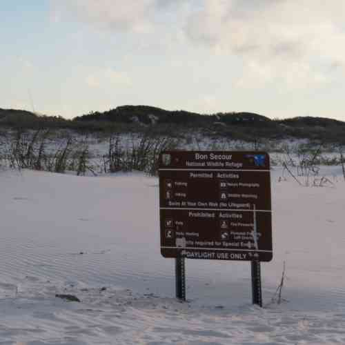
People curse the endangered species act, but thankfully that is what has saved a 5 mile stretch of natural beach where we prefer going. The Alabama Beach Mouse is responsible for the creation of Bon Secour National Wildlife Refuge
A last vestige of the natural ecosystem in a an ever expanding recreational development and resource extraction.
https://www.youtube.com/watch?v=06ijlV-Wz2c (1 min intro)
Take this 3 min walk through the maritime forest, across the pine scrub, past the brackish lake, through the dunes, and on to the beach across one of the last natural stretches of beach in Alabama
https://www.youtube.com/watch?v=EYZVYb3zrY0
A better quality 3 min video with random shots.
https://www.youtube.com/watch?v=gzFM6ewJsFQ
5 min drone footage
https://www.youtube.com/watch?v=Ic3y-Tt2rV4
A news story descibing why we choose why we choose go here (2 min)
https://www.youtube.com/watch?v=aFjmJqWDPkk
What is so nice about Bon Secour...
There isn't much natural beach ecosystem remaining but here's one on the redneck riviera
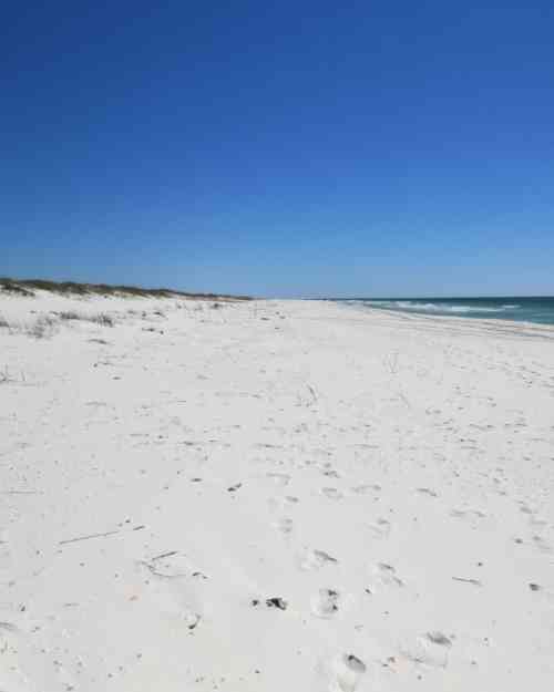
Complete with a dune system...
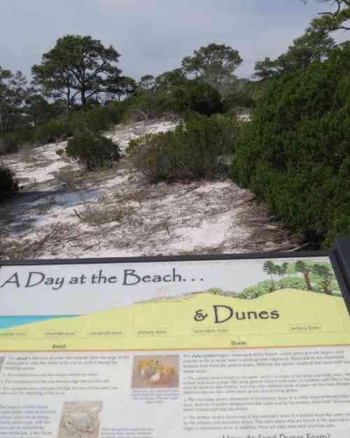
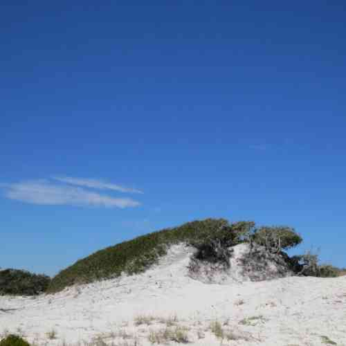
Waves erode beaches and dunes along one area of the shoreline and the longshore current sweeps along the shore, depositing the sand elsewhere. The size and form of dunes found along the Atlantic Coast are highly variable and dependent upon many factors: strength and direction of prevailing winds, vegetation cover, nature of the backshore environment, and the rate at which sand is removed from the beach.
Plants hold the beach. Sand collects around plants, creating the characteristic patchwork of hillocks and swales. Beaches with wide, flat intertidal zones expose a large sand source for building dunes.
https://www.beachguide.com/blog/southwest-florida/beach-plants-and-sand-...
A dune system can be divided into three zones: (1) strandline and embryo dune zone, (2) primary dunes (also called foredunes or yellow dunes), and (3) secondary dunes (also called hind-dunes or grey dunes).
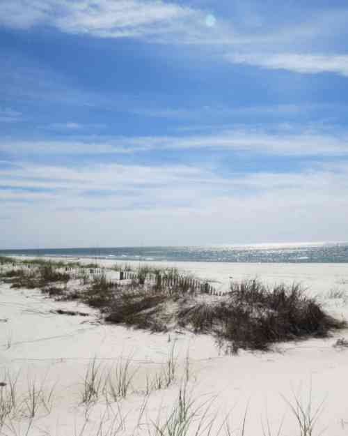
Here's an example of building a fore dune using fencing.
The hind dune is covered with salt pruned vegetation
The highest active dune system in the eastern United States is Jockey's Ridge, located near Nags Head on the Outer Banks of North Carolina. This highly mobile dune, which changes in elevation as it moves, measures up to 33 m in height. Other large dunes on the Outer Banks reach 20 m in height (e.g., Jones Hill and Penny's Hill). Mount Ararat, on Cape Cod, Massachusetts, is about 30 m in height, whereas the highest dune elevations on Cumberland Island, Georgia, are 12 m.
http://people.uncw.edu/hosier/BIE/bieclschd/present/dneslkmorph.htm
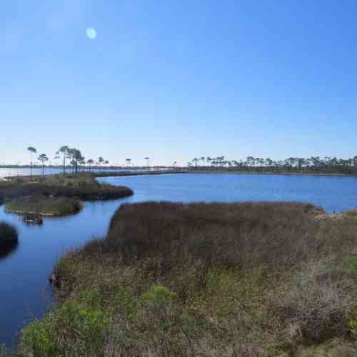
Behind the dunes are forests (first Pines then Live Oak) and wetlands (both fresh and brackish water).
Behind the dunes are often fresh and brackish water wetlands.
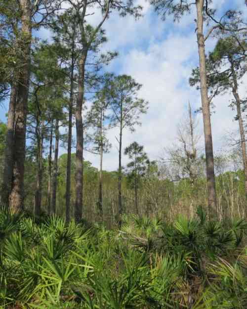
Piney woods grade into he dune system too.
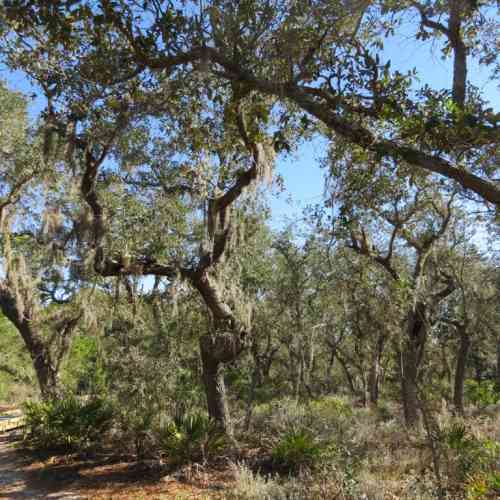
And at last behind the dune system are the lovely maritime forests of Live Oak draped in Spanish moss
Along ocean shorelines, sea-level rise is usually translated into a general landward retreat of the beach and dunes. Environments nearest the ocean shoreline are likely to be destroyed as the dunes erode. Sea-level rise models for wetlands show a landward shift.
An unexpected dinner guest, but they came with their own meal in hand (or talon)

At lo-res it is difficult to see Mercury to lower right of Venus

The dots on the horizon are natural gas rigs

So we'll leave the Fort Morgan and move on...

Well it is nearing the end of the trip and it is time to go over the ferry and through the woods with a quick stop. How about a quick look at Bellingrath Gardens? Walls of azaleas are in bloom...


Will we ever find our way back to the garden? There are individuals who seem to to know nature's tune...the divine symphony. I think Walter Anderson was such an individual. We're ending our trip in Ocean Springs Mississippi to see the work of Walter Anderson, one of our beloved artist.
https://en.wikipedia.org/wiki/Walter_Inglis_Anderson

https://www.youtube.com/watch?v=pxmehXLO8Ag an illustrated short story about Walter.
Look at some of his work here -
https://walterandersonart.com/

We were lucky to hear a discussion of the role of cats in his work by his daughter, Mary. I learned in part what attracts me to him. He gave Mary a two volume Funk and Wagnall edition of Folklore, Mythology, and Legend when she was a child which he told her contained everything she needed to know.
His son, John, describes his work...as visual music.
https://www.youtube.com/watch?v=-vxyk-tZtX0 (9.5 min)
Lovely montage of Walter's work with Don McLean's “Starry Starry Night”
https://www.youtube.com/watch?v=g_s1v94tCj0 (5 min)
This original song about Walter is by an Atlanta artist who spent her summers at camp on Lookout mountain. https://www.youtube.com/watch?v=--RMxPB7h-w 5 min song

Time to head home....
We traveled south on the Alabama River system. Let's return home in the 1500's with Tristan de Luna who is given credit for establishing the oldest established European multi-year settlement in the United States in the heart of Pensacola.
https://www.pnj.com/story/news/2015/12/17/we-found-lunas-colony/77449884/
Tristán de Luna is ordered to establish a Spanish settlement on the Gulf Coast and an overland trade route to what is now South Carolina. After his Pensacola landing, they were hit by a storm before they could unload the vessels. On the night of September 19, 1559, a hurricane (with storm surge) swept through and destroyed most of the ships and cargo: five ships, a galleon and a barkm, pushing one caravel and its cargo into a grove inland. With the colony in serious danger, most of the men traveled inland to the Alabama River to the village of Nanipacana which they had found abandoned
http://www.ourgeorgiahistory.com/ogh/Tristan_de_Luna
https://en.wikipedia.org/wiki/Trist%C3%A1n_de_Luna_y_Arellano
Historians believe that a series of epidemics nearly wiped out southeastern tribes in only decades. One of them—possibly a combination of pneumonic and bubonic plagues, or typhus— killed millions of Mesoamericans from 1545 to 1548. Colonists also transmitted the influenza virus to Native peoples. The virus became epidemic in the Caribbean and Mesoamerica in 1559, following its sweep across Europe two years earlier.
https://www.nlm.nih.gov/nativevoices/timeline/189.html
They headed up the Coosa River, which meanders through northeast Alabama and northwest Georgia, but when the Spanish entradas of Hernando de Soto, Tristan de Luna, and Juan Pardo first set foot in the region between 1539 and 1568, Coosa had a very different connotation. First, Coosa referred to the town of Coosa, which moved to several different locations over its existence. Secondly, the Chiefdom of Coosa was limited to the Coosawattee River Valley, which extended from southern Tennessee, through northwest Georgia, finally ending in northeast Alabama. When Spanish expeditions trampled through the region, they commonly referred to it as the Province of Coosa - an alliance of several chiefdoms from central Alabama to eastern Tennessee, all under the leadership of the Coosa cacique. The Coosa people possibly created the largest complex paramount chiefdom in sixteenth-century southeastern North America.
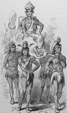
The structural makeup of a Mississippian chiefdom and its governing body in the1540s was more advanced than the Spanish gave credit. A chiefdom normally had anywhere from 100-1500 permanent residents living within its borders. The typical chiefdom had a town that served as the capitol, while several smaller, outlying towns paid tribute to a central cacique. At least one archaeological model illustrates that less complex chiefdoms consisted of a cluster of towns with a large capitol town normally containing several mounds. The cacique used his food surplus for supporting part-time artisans that made special goods for those who could afford them and for supporting the chiefdom's warriors. Coosa began as a simple chiefdom, incorporating a minority of towns and clans with minimum overall development and limited ranking caciques. By the time Hernando de Soto's expedition entered Coosa, it was definitely a complex paramount chiefdom, incorporating numerous social and kin groups that found their ways into the "political hegemony of a powerful paramount chief" as the results of military conquests. These "low-ranking" tributary chiefdoms and towns established political alliances to the paramount cacique through marriage and the placement of his relatives in authoritative positions over the conquered towns.
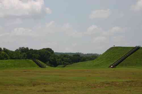
Towns in Mississippian culture serving as boundaries to the chiefdom were often fortified with palisade walls, defensive towers, and defensive ditches. The capitol town contained the cacique's house, a temple or temples, and other important public buildings. Natives built most of these public buildings atop pyramid shaped, flat-topped, earthen mounds that took several years to construct. Primarily, these mounds elevated the elite class above the commoners and asserted the cacique's power over his surrounding chiefdom. Normally, a plaza, neighbored by or enclosed by the capitol's public buildings and residents' homes, supported recreational activities. According to the Soto reports, the elite inhabitants lived near the caciques dwelling on the edge of the plaza, while the lower classes dwelt near the outskirts of town. https://www.nps.gov/chch/learn/historyculture/coosa.htm
He expects to find villages of the powerful Coosa people, which Hernando de Soto described 20 years earlier. Instead, he finds villages almost abandoned. An ailing slave left behind by de Soto had spread an epidemic that swept through Coosa towns.
So I'm following the River system home today...headed upstream along the interstate highways following de Luna's journey. He was searching for food and survival, I'm content, buoyed by a nice stay on the beach, visits to gardens, nature preserves, and immersed in the delight of art. Getting out of our routine helps us to view the world with different eyes. Perhaps I gained some vision from the nature of the shore, inspiration from Walter's work, and the wisdom of this Mama and baby who took advantage of an osprey nesting platform.

I look forward to your insights and stories when I get home.
--------------------------------------------------------------------------------------------------
This year's trip was similar but different. We'll catch up next week!

Comments
Thanks for the gulf shore tour
.
.
A lot to learn from your essay. Not familiar with that section
of the coast, always seemed to skip it on my explorations.
Hope Helene did not tangle you up.
Cheers!
Zionism is a social disease
Nice, also a great respite from all of the gnus.
Today we're heading inland, so just the opposite. Instead of tides and dunes, we are going where tectonic forces have repeatedly overwhelmed everything. Still, also a respite if we opt not to search for gnus and instead just be there. Dunno 'bout photo ops, but there should be majestic scenery, which I'm not talented enough to shoot on the fly, especially when it's my shift behind the wheel.
be well and have a good one
That, in its essence, is fascism--ownership of government by an individual, by a group, or by any other controlling private power. -- Franklin D. Roosevelt --
Gaza
https://youtu.be/kPE6vbKix6A?si=hw52TTbgMBtMr_Fy
@la58 It's been a long time
It's been a long time since I Commented here but I think everyone should watch this.
thanks for adding to the mix
.
.
war crimes-R-US
will check it out
welcome back
reminds one of this
Zionism is a social disease
Encore Azaleas and Ocean Springs, MS
Enjoyed your travel log of the Gulf. Bellingrath Gardens is a real treat, and those encore azaleas are a nice touch this time of year. Ocean Springs, MS is a hidden jewel, as well. Many people skip the Mississippi/Alabama coast and hurry over to Florida on their travels. They don't know what they are missing.
Thanks Lookout for the change of pace in this weeks
Weekly Watch and I hope you had an enjoyable vacation.
However. Sadly things world wide remain much the same if not worse.
Ha…ha ha ha….
How spot on is that?
The message echoes from Gaza back to the US. “Starving people is fine.”
Wow…
.
Just wow. Recently CJ Hopkins was found guilty for promoting Nazism in Germany after his first trial that cleared him. The new normal sucks.
Fear and loathing in the new normal Germany
Indeed. Doctors in Germany who wrote a mask exemption have been persecuted beyond all sanity for it. This folks is what medical tyranny looks like.
The message echoes from Gaza back to the US. “Starving people is fine.”
After the Berlin Wall fell..l
.
there was so much hope in the world that we would finally have world peace. But…l
The message echoes from Gaza back to the US. “Starving people is fine.”
Caitlin has something to say and it is a doozy.
The rest of the tweet:
Not fighting "terrorism". Not spreading freedom and democracy. Not even protecting Israel. It's ultimately about controlling what happens in a geostrategically crucial and resource-rich stretch of land.
The people who live in that part of the world never did you any harm. They pose no threat to you. You're only being told to hate them because the world's most powerful people need to dominate west Asia in order to dominate the planet, and they need to inflict immense amounts of violence in order to do so. That's all this is.
Our rulers use all kinds of narratives from all around the world and across the political spectrum to justify their actions. They'll use Zionism, Christian fundamentalism, Islamic fundamentalism, Hindu fundamentalism, liberalism, conservatism, nationalism or woke identity politics to manufacture consent for their agendas wherever needed. They'll feed you whatever lines you need to hear in order to dupe you into thinking that disobedient populations in the middle east need military explosives dropped on them. That's all they care about.
Our rulers use their propagandists in the mainstream news media and their narrative managers in Silicon Valley to manipulate public perception toward these murderous agendas using half-truths, lies by omission, distortions, misleading headlines, reversing the victim and the aggressor, starting the timeline of events at convenient points, and uncritically repeating unproven allegations from untrustworthy sources. These manipulators are as critical to the operation of the imperial war machine as the actual people who drop the bombs.
What kind of groveling, slobbering bootlicker would play along with this? What kind of power-worshipping empire simp would consent to murder and abuse at mass scale against people who pose no threat to them whatsoever, just because the people in charge told them to feel that way? What a pathetic, profoundly undignified way to exist.
They work so hard to manufacture our consent for these atrocities because they absolutely require our consent. So don't give it to them. When all is said and done our rulers are at all times acutely aware of the fact that there are a whole lot more of us than there are of them, and that we could very easily turn around and eat them all if we got it into our heads that that would be a good thing to do. Hold fast to your power, refuse to be taken in by their manipulations, and help wake everyone up to the fact that we are being continuously deceived into compliance, confusion and powerlessness by murderous psychopaths who want to rule the world.
Our real enemies are not in Iran.
Our real enemies are not in Lebanon.
Our real enemies are not in Gaza or the West Bank.
Our real enemies are not in Yemen, Syria, or Iraq.
Our real enemies are in Washington and London and Tel Aviv. In Berlin and Paris and Canberra. In secretive government agencies in the state of Virginia, and in imperial propaganda institutions in New York and Hollywood.
Our real enemies are not the Arabs and the Iranians, they're the managers of empire who are ruining our world, destroying our biosphere, siphoning our wealth and our resources, threatening us with nuclear brinkmanship, and making sure we stay too poor, sick, busy and brainwashed to figure out what's going on and take a stand against them.
Don't let them dupe you into believing otherwise. Fight against their manipulations, and oppose their abuses. We healthy human beings can absolutely win this thing, but even if we don't, at the very least we can prevent them from stealing our dignity and manipulating us into cheering for their depravity.
Our "enemies"
are all countries on the globe that have a natural treasure we want. It might be oil, rare minerals, farm land, ports, water, strategic location, or food. We war for fish, we war for bananas.
"We'll know our disinformation program is complete when everything the American public believes is false." ---- William Casey, CIA Director, 1981
Nowadays I encourage people to vote for the AfD, not because
I necessarily agree with their ideas or think they would do any better if in power, but simply to get the smug, warmongering elite folks’ goat and gum up the works a little.
Hi weekly watchers
Hi all, Hey LO!
GREAT WW man! Coastal habitats are awesome. From tidal areas to dunes, then marshes, and finally uplands with real trees. All those great habitats, and diversity. Great pics you have there of them. So much of our coastlines have been developed it is mind-boggling. They build right down to the waves, only the water stops them. The little postage stamps of habitats left are more valuable than ever.
Thanks for the WW LO!
happy trails all!
We cannot solve our problems with the same thinking we used when we created them.
Look deep into nature, and then you will understand everything better.
both - Albert Einstein
Good afternoon, LO!
I have enjoyed staying at Gulf Shores 4 or 5 times, did get a glimpse of Bon Secour.
We typically drive straight through MS, but you have given me the idea of planning an overnight stay to explore the sites you and karl pearson have mentioned.
I enjoyed the videos, learned a lot, appreciated the art, and the photo of the ospreys.
It was really nice of you to post this at your vacation time.
Many thanks, dear friend.
"We'll know our disinformation program is complete when everything the American public believes is false." ---- William Casey, CIA Director, 1981
Cook has been calling out British media
.
for its coverage of the Gaza genocide, but he seems absolutely livid about this article.
The message echoes from Gaza back to the US. “Starving people is fine.”
Only one country in all of history
can do no wrong.
(must go vomit)
"We'll know our disinformation program is complete when everything the American public believes is false." ---- William Casey, CIA Director, 1981
600,000 Americans are living on the streets
This is just one report from one city in America so it’s easy to see why fema can’t find any money for people affected by the hurricane.
Col. MacGregor says some migrants are handed a debit card loaded with $2,000 that is renewed every month. Meanwhile….600,000 Americans are living on the streets and military families are living in homes that should be condemned. Black mold and other lovely things inside the homes that are owned by 3rd party companies. They have been complaining about for decades and yet the government doesn’t make the companies bring the homes up to code.
The message echoes from Gaza back to the US. “Starving people is fine.”
Hezbollah is using bigger missiles
And rumors are that Iran is moving its mobile missile launchers.
There are Irish peacekeepers in Lebanon and Israel is parking its tanks right next to them. I guess that’s called using human shields? Bunch of cowards getting their butts kicked on the ground. At least 20 dead and twice that wounded. Fighting people who can fight back is hard…
The message echoes from Gaza back to the US. “Starving people is fine.”
A tribute.
Never forgotten
n/t
"We'll know our disinformation program is complete when everything the American public believes is false." ---- William Casey, CIA Director, 1981
Scott Ritter tells it like it is!
Worth viewing.
Only took him just over 3 minutes
to tell it like it is.
VERY powerful, humphrey.
"We'll know our disinformation program is complete when everything the American public believes is false." ---- William Casey, CIA Director, 1981
More bad weather
and more tragedy.
Chaing Mai, Thailand, is bordered by the Ping River. The recent typhoon caused heavy rains, and the Ping rose 17 ft, flooded the city, as well as a total of 20 provinces.
Elephants were used for rescues. However, the famous elephant habitat where I was kissed by a baby elephant, where I rode an elephant across a river, likely the Ping, lost 2 elephants.
I have a picture, an actual painting by one of those elephants, that I had framed.
May the 3 people who died, and the 2 elephants who drowned, rip.
https://www.aljazeera.com/news/2024/10/7/at-least-three-killed-as-floods...
"We'll know our disinformation program is complete when everything the American public believes is false." ---- William Casey, CIA Director, 1981
US is getting tough with Israel. HAH!